|
The following is basic logistical information to help you plan your run. Please keep in mind that The Foothills Trail is a very rugged and often remote wilderness area with little to no outside access. Great care should be taken in organizing your trip and always be sure to let several people know your itenerary. This is only general information and I take no responsibility for what could happen to you out there. This should not be treated as a casual stroll in the forest.
If you hide aid on the trail please be sure to clean up what you leave behind! NEVER LITTER!
At the time of this writing the trail is marked very well with white blazes and signs. I would advise you to always check The Foothills Trail official website for up to date information. They also have an excellent profile map of the trail.
Let's break the 76.2 mile trail down into four major sections below. I suggest that you have someone providing aid/support to you along the run from their vehicle. This gives you a net of safety and nearly guarantees that you will have what you need along the way. Many runners will choose to camp at Table Rock State Park the day before the run. There are also cabins and camping at Oconee State Park.
1.
Table Rock (14.5 Miles) starts with a
steep 4 mile climb, levels off, then steadily climbs to Sassafras
Mt. (SC's Highest Peak). After this, you have 4.8 miles of nice
downhills. Possible aid points at 9.7 Miles (Top of Sassarfas) and at the
end of this section at Laurel Valley at 14.5 miles. You will have a hard
time finding water through here so bring enough to get you through.
2.
Laurel Valley
(33.4 Miles) begins in a gravel parking lot off HWY
178. This section is very strenuous and remote. There are no support
areas through here so you need to stock up before heading in. After
the initial climb from the parking lot you will have some nice
runnable single track & fire-road for about 8-9 miles. There are
several steep climbs including a final one at the end of the section that brings you out past
Whitewater Falls at mile 47.9 on HWY 130 (Whitewater Falls Road).
If you do run into trouble through this section your only escape will be by finding a boat ride off Lake Jocassee or hiking out through Gorges State Park. It's mostly uphill on the way out and you end up in the middle of nowhere, NC. Well, Rosman, NC actually. If you're lucky, you may get a signal on your phone to let someone know where you are. But 5 miles out is easier than 20+ miles if you can get someone to pick you up. There are two trails that merge off the Foothills trail taking you to Gorges State Park:
Canebrake Trail (5 Miles Uphill) is just past the Toxaway
River Bridge
Auger Hole Trail (7 Miles Uphill) is about 17 miles into this
section at the powerline cut.
Map to Gorges State Park Frozen Creek Parking Lot Where Canebrake
Trail Begins
GPS Coordinates: N35 06.511 W82 53.019
3.
Whitewater Falls to Burrell's Ford (12.2 Miles). 3 mile
switchback climb out of WWF which takes you to a road crossing
called Sloan's Bridge. Support can be had here. Some of this section
is technical, but after the initial climb from WWF, there are no
more major climbs in this section. As you leave Sloan's Bridge you
head gradually uphills towards the Fish Hatchery which is about 3.3
miles. Aid can be had here too. From here there is an awesome 3.5
mile downhill section towards Burrell's Ford where you meet up with
the Chattooga river. Aid is possible here too.
4.
Burrell's Ford To Oconee State Park
(16.1 Miles). There are no
major climbs in this section either. However, the trail does get
rather technical in places along the river. There is no support
areas through here until you reach Cheeohee road about 10 miles in.
The trail is moderate to easy for the final 6 miles heading into
Oconee State Park.
So, Aid/Crew Access is avaialable at: GPS Coordinates
| -Sassafrass Mt. 9.7 Miles -Laurel Valley Access 14.5 Miles -Upper Whitewater Falls 47.9 Miles -Sloan Bridge 52.6 Miles -Fish Hatchery 55.9 Miles -Burrell's Ford 60 Miles -Cheohee Road 70.2 Miles |
35 03.870 82 46.620 35 02.938 82 48.828 35 03.862 82 46.572 35 00.198 83 03.246 34 58.619 83 04.410 34 58.261 83 06.894 34 54.946 83 06.714 |
Clicking on each location above will bring up a new window with Google Maps.
Here is a helpful fly over of the entire trail showing you where the access points are on a map.
If you plan to
drop your own aid out before your run I recommend following this
route when you drive. If you have a crew helping you they may
find this information helpful as well.
1. From Oconee State Park turn right out of the park onto HWY 107.
Your first drop will be at Cheohee Road which will be on the right
side of the road. There is a small area for a few vehicles to
park and you will see Foothills Trail signage here. There are
several good areas to hide aid here.
2. From Cheohee Road
turn right back onto HWY 107 for a few miles. You will see a
sign pointing towards Burrell's Ford to the left. Take the
left and drive down the gravel road until you see FHT signage and a
large gravel parking lot on the left.
3. Drive back up the gravel road and take a left to continue
onto HWY 107 towards Fish Hatchery. Again, you will see a sign
pointing you towards the Fish Hatchery to the left. Turn onto
the road and you will drive to small parking area where you will see
FHT signage.
4. Head back to HWY 107 and turn left to continue to Sloan
Bridge. You will drive past State Road S-37 413 (Wiginton
Road) on the right. After you pass it you will see a sign for
Sloan Bridge on the left. Pull off here and you will see where
the trail crosses the road.
5. Now backtrack on HWY 107 to State Road S-37 413 (Wiginton Road) and take a left onto it. This will take you towards Whitewater Falls. Drive to the end of Wiginton Road and take a left onto HWY 130 (Whitewater Falls Rd). You will pass Bad Creek Project gate on the right and immediately afterwards you will see a Nantahala Forest Sign and large dirt parking area on the right. Pull into the dirt parking area and you will see where the trail crosses over HWY 130.
6. Turn left out of the parking lot onto HWY 130 and follow it until you come to HWY 11. Turn left onto HWY 11 and follow it until you arrive at the intersection of HWY 178. Turn left onto HWY 178 and drive about 8 miles until you enter the town of Rocky Bottom. You will cross over the Estatoe Creek bridge and immediately after it turn left onto the gravel road. Stay right on the road for about a quarter mile and you will see a large Foothills Trail Sign and parking area on the left. This is the Laurel Valley parking lot entrance.
7. Backtrack down the gravel road and turn right onto HWY 178. You will quickly come to Vanclayton Memorial HWY (Sassafras Mountain RD) on the left. Turn onto it and follow it for several miles to the top of the mountain. There will be a sign for Chimney Gap where the trail corsses before reaching the top if you would like to drop aid there. Or just continue driving to the top of the mountain. The road gets steep at times, but you can safely make it up in any vehicle as long as there is no ice.
8. Backtrack back down and turn left onto HWY 178. Follow it back to HWY 11 and turn left which will take you to Table Rock State Park. The trailhead is at the science center in the park. You will find plenty of paved parking and bathrooms there.
Other factors to keep in mind -
Table Rock & Oconee State Parks may lock their parks during certain hours or times of the year. Check with them before your run. Neither of the parks allow you be on their trails after daylight.
Be sure to leave your vehicle(s) in designated areas while in both parks.
Please consider making a time or money donation to The Foothills Trail. You will be amazed at the amount of time, money, and effort that has went into making this such a beautiful trail!
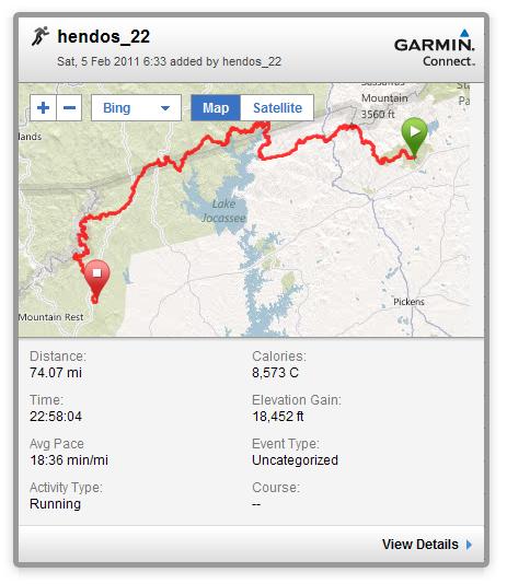
Garmin GPS Results From Runner - Watch went dead with a few miles to go before reaching Oconee State Park.